Εμφάνιση αναρτήσεων με ετικέτα Pacific Ocean. Εμφάνιση όλων των αναρτήσεων

Σάββατο 15 Νοεμβρίου 2014

7.3 quake hits Indonesia waters (tsunami possible)

JAKARTA — A 7.3-magnitude quake hit Indonesian waters, off the Moluccas, this morning (Nov 15) and has the potential to generate tsunami waves along nearby coasts, a monitoring agency said.

According to the US Geological Survey (USGS), the quake hit 154km northwest of Kota Ternate at a depth of 47km.
There are no immediate reports of casualties or damage.
The Pacific Tsunami Warning Center said the quake could cause hazardous tsunami waves within 300km of the epicentre along the nearby coasts of Indonesia and the southern Philippines. Waves could reach up to a metre or less, it said.
The nearest communities of Tabukan Tengah on North Sulawesi island could be at risk within an hour or so if a tsunami occurs, the agency said.
The waves could also reach as far as Taiwan, Okinawa in southern Japan, the US territory of Guam, Papau New Guinea, Solomon Islands and the Marshall Islands in the Pacific within the next six hours, it said.
Another quake measuring 6.2 was recorded soon after off Indonesia’s Sulawesi, according to the USGS.
The world’s largest archipelago, Indonesia is prone to earthquakes due to its location on the Pacific Ring of Fire, an arc of volcanoes and fault lines in the Pacific Basin.
In 2004, a monster temblor off Aceh shores triggered a tsunami that killed 230,000 people in a dozen countries. Most of the deaths were in Aceh. 
AGENCIES
http://www.todayonline.com/world/asia/73-quake-hits-indonesia-waters-tsunami-possible
15/11/14
-
--

Κυριακή 5 Οκτωβρίου 2014

Only 26-meter tsunami could now damage Fukushima – (TEPCO)

The operator of Japan's crippled Fukushima nuclear plant has raised the tsunami projectile height, saying it would take a 26-meter wave to damage the facility and cause radioactive leakage, local media reported. This comes as Japan faces a typhoon threat.

Officials from the Tokyo Electric Power Company (TEPCO) have nearly doubled the previous projected tsunami height that would inundate the Fukushima Daiichi nuclear plant – raising it from 14 to 26.3 meters, Asahi Shimbun reported on Saturday.

The flood caused by such a tsunami would “likely cause seawater to mingle with the radiation-tainted water accumulating in the basements of the reactor buildings at the six-unit plant, allowing 100 trillion becquerels of cesium to escape,” The Japan Times reported, citing TEPCO officials.

  • However, TEPCO officials noted that such a strong tsunami occurs only once every 10,000 to 100,000 years.

The operator also increased the scale of a potential earthquake that would damage the plant by 1.5 times to 900 gals, media reported.

The company’s statement made on Friday comes in response to a demand made by Japan’s Nuclear Regulation Authority (NRA) for the operator to review tsunami counter-measures. The authority is to decide whether TEPCO’s figures are suitable.

Following the March 2011 earthquake that triggered a 15.5 meter tsunami and hit the Fukushima Daiichi plant – causing three nuclear core meltdowns – the NRA obliged other facilities to strengthen tsunami counter-measures and raise the scale of the highest tsunami protection. But the new regulation did not apply to Fukushima, which is over 40 years old, as the plant was to be decommissioned.

As a measure to reduce the impact of a potential hit by a huge seismic wave, TEPCO said it will cut the quantity of radioactive water stored on the premises of the facility. Thus, the amount of radioactive water leaked into the ocean would be reduced by 30 percent, Asahi reported.

In the wake of the 2011 tragedy, Japan shut down all its nuclear reactors. However, the Japanese government has been keen on the nuclear restart, insisting that the reactors are necessary to provide cheaper energy to the economically-challenged Asian nation.............
Will Typhoon Phanfone affect Fukushima?........http://rt.com/news/193364-tsunami-damage-fukushima-tepco/

5/10/14
--
-
Related:

Σάββατο 4 Οκτωβρίου 2014

NASA Satellite Images Reveal Shocking Groundwater Loss in Drought-Stricken California

NASA’s Gravity Recovery and Climate Experiment (GRACE) program has released a series of satellite images, taken in June 2002, June 2008 and June of this year, showing the  stunning groundwater loss in California which is in its third year of record drought.... 

“This trio of images depicts satellite observations of declining water storage in California as seen by NASA’s Gravity Recovery and Climate Experiment satellites,” says NASA. “Colors progressing from green to orange to red represent greater accumulated water loss between April 2002 and June 2014.”

The prolonged drought has impacted everything from agriculture to fisheries to residential use, worsened and prolonged the wildfire season and created conflicts over the use of water resources.
That has included calls for banning water-intensive fracking and disputes over the diversion of river water for the state’s even more water-intensive agriculture sector, primarily in its fertile Central Valley.

“California’s Sacramento and San Joaquin River basins, including the Central Valley, have suffered the greatest losses, in part due to increased groundwater pumping to support agricultural production,” said NASA. “Between 2011 and 2014, the combined river basins have lost 4 trillion gallons of water each year, an amount far greater than California’s 38 million residents use in cities and homes annually.”

Gov. Brown declared a state of emergency in January after the state had its lowest recorded rainfall in its history.

*** GRACE is a collaborative endeavor involving the Center for Space Research at the University of Texas, Austin; NASA’s Jet Propulsion Laboratory, Pasadena, Calif.; the German Space Agency and Germany’s National Research Center for Geosciences, Potsdam.


Anastasia Pantsios | October 3, 2014
ecowatch.com
--
-
Related:

---

Fukushima To Be Hit By Typhoon, Causing Ocean Contamination (Tepco)

MOSCOW, October 4 (RIA Novosti), Ekaterina Blinova - Tepco, the Tokyo Electric Power Company, has revealed that the approaching typhoon could hit the damaged, decommissioned 40-year old nuclear power facility Fukushima No.1, which was severely affected during the earthquake and tsunami in 2011.

"The deluge would likely cause seawater to mingle with the radiation-tainted water accumulating in the basements of the reactor buildings at the six-unit plant, allowing 100 trillion becquerels of cesium to escape, according to an estimate that Tepco revealed Friday at a meeting of the Nuclear Regulation Authority," the Japan Times reports.
According to the media outlet, tidal waves from the storm are likely to reach a maximum height of 26.3 meters or more. The storm is likely to strike the Fukushima No.2 nuclear plant as well, but "its idled reactors and fuel pools" are not expected to be destroyed, Tepco officials assert.
  • It should be noted that the 2011 tsunami reached a height of 15.5 meters when it hit the plant, which was followed by a 9.0 magnitude earthquake.

In order to minimize the impact of the hurricane, Tepco "will reduce the vast quantity of radioactive water" on the site, the Asahi Shimbun notes. Citing Tepco's officials, the media source claims that the amount of contaminated wate, which is expected to spill into the ocean, could be decreased to 30 percent "by filling in trenches near reactors."..................http://en.ria.ru/world/20141004/193667366/Fukushima-To-Be-Hit-By-Typhoon-Causing-Ocean-Contamination-Tepco.html
4/10/14

Κυριακή 28 Σεπτεμβρίου 2014

Fukushima Water Treatment System Fails Again

A water treatment system to decontaminate radioactive water at Fukushima nuclear plant fails again and thus had to be partially shut down, Japan's NHK news agency reported Saturday.

According to the plant's operator, Tokyo Electric Power Company (TEPCO), the trouble could have been caused by faulty filters.

One of the three lines of the Advanced Liquid Processing System (ALPS) was turned off after the engineers found out that the water contains calcium, hindering the elimination of radioactive strontium.


Since March, the ALPS system at Fukushima has had a series of similar failures. TEPCO then replaced the filters and resumed the system operations, highlighting company's plans to set up another facility to treat the tainted water.

On March 11, 2011, the Fukushima nuclear power plant was hit by a powerful earthquake and a subsequent tsunami, which caused a partial meltdown of three of the plant's nuclear reactors as radiation leaked into the atmosphere, soil and sea.

The incident was the world's worst nuclear disaster since the 1986 Chernobyl catastrophe.

Several areas within the 20-kilometer (12 miles) zone from the plant are still considered unfit for habitation due to the high levels of radioactive contamination.

TEPCO has been widely criticized for being inadequately prepared for a tsunami and for its slow response to the disaster.

Cleaning the toxic waste from the abandoned nuclear plant and reactors decommissioning have become the principal task of TEPCO, the process of disaster cleanup is expected to take at least 40 years.

en.ria.ru
27/9/14
--
-
Related:

Πέμπτη 25 Σεπτεμβρίου 2014

US to create world's largest marine reserve in Pacific

The United States is to create the world's largest marine reserve, stretching over about 1 million 270,000 square kilometres of the Pacific ocean, the White House press service said.

US President Barack Obama will sign the bill on Thursday, setting out plans for a new environmental zone encompassing seven desert islands and coral atolls existing under US juridiction.


The current Pacific Remote Islands National Marine Monument territory between the Hawaiian islands and Samoa will be expanded sixfold to become a marine-protected area (MPA).The zone will ban any business activity there, including commercial fishing and mining operations.

American scientists believe the region has a tropical marine environment with unique animal and vegetal life that needs protection, seeking to defend deep-sea coral reefs thought most vulnerable to the impacts of climate change.

http://en.itar-tass.com/non-political/751198
25/9/14
--
-
Related:

Δευτέρα 25 Αυγούστου 2014

Effectiveness of Fukushima Ice Wall Unclear to Experts

MOSCOW, August 25 (RIA Novosti) - The effectiveness of Tokyo Electric Power Company’s (TEPCO) plan to create an “ice wall” to contain the waste water used to cool the failed reactors at the Fukushima Daiichi nuclear power plant is so far unclear to experts.
"As the water comes down the mountains towards the ocean, it's not clear to me that [TEPCO] really knows how it is going to move around that frozen barrier," former US Nuclear Regulatory Commission chairman and the head of the international advisory panel to TEPCO Dr. Dale Klein said in an interview with VICE News, published Sunday.

Along with the other experts, Klein is worried by TEPCO not keeping the public informed about the dangers currently posed by the failed reactors. "They give off the perception that they're covering up something, when that isn't what they're doing at all," the analyst said.
TEPCO officials have repeatedly been accused of negligence and not sharing enough information with the public. Three months after the March 2011 catastrophe, The Wall Street Journal released a report based on interviews with TEPCO engineers, saying the company knew some of its reactors were incapable of withstanding a tsunami.
In August 2013, TEPCO admitted that 300 tons of highly radioactive water had leaked from the nuclear power plant, significantly more than the public was led to believe.
And early in August 2014, the company revealed that all the fuel rods in Fukushima Daiichi reactor three have apparently melted down, while in November, 2011, it was estimated that only 63 percent of the reactor’s fuel cord had melted.
The Fukushima Daiichi nuclear power plant was severely damaged after a 9.0 magnitude earthquake and subsequent tsunami hit the plant in March 2011, leading to the extensive leakage of contaminated water into the surrounding environment.

The negative effects of the Fukushima nuclear disaster are still being felt. Last week, Fukushima Prefecture officials announced that the number of young people diagnosed with definitive or suspected thyroid cancer, a disease often caused by radiation exposure, has reached 104. To illustrate the negative effects the disaster has had on animals and insects, researchers cite the example of the pale grass blue butterfly, which has seen a reduction in size and an increased mortality rate in the region.

In June 2014, TEPCO began to erect a mile-long underground wall of ice around the damaged reactors to stop toxic water from leaking into the Pacific. Later that month the company said it was having trouble with the construction of the wall, as the pipes carrying the coolant were unable to freeze the ground. Still, in July TEPCO decided to move forward with the ice-wall plans, hoping to complete construction by March 2015.
 http://en.ria.ru/world/20140825/192327162/Effectiveness-of-Fukushima-Ice-Wall-Unclear-to-Experts.html
25/8/14
--
-
Related:
 

Πέμπτη 14 Αυγούστου 2014

Panama Canal Turns 100 Amid Growing Pains, Competition

The Panama Canal turns 100 this week. Officially opened in 1914, the 77-kilometer channel joins the Atlantic and Pacific Ocean at the isthmus of Panama.  It made the world smaller, creating a shortcut for cargo ships that ply their trade from east and west.  But 100 years later the canal is straining from the demands of expanding global trade.  It may also be facing some serious competition as it navigates the next 100 years.
Taking over 30 years to build, tens of thousands of workers - and more than 27 million kilograms of dynamite - it is considered one of the biggest engineering feats of the 20th century.  

"The Panama Canal is one of those phenomenal moments in history.  A terrific example of engineering and technological strength of the United States, and really the coming of age of the United States as a global power," said University of Maryland Professor Julie Greene, author of the book "Canal Builders."
  • But the work exacted a heavy toll.  By the time the first ship crossed the canal, nearly 26,000 workers had died, some from accidents, many from malaria.
But it also changed international commerce forever, especially in the U.S., says George Washington University professor, Noel Maurer.
“Because it enabled for the first time oil from California and lumber from the Pacific Northwest, but it was really the Californian oil that was driving the boat, to be profitably exported from California to the rest of the United States, and that had huge economic benefits for the United States," Maurer said.
Today more than four percent of the world's commerce passes through the canal - some 14,000 ships per year. But the canal's locks are now too small for much of the world's container fleet and the largest oil tankers.
Transportation expert Rodney McFadden says bigger ships can be more efficient and profitable.

“They carry more cargo for about the same amount of money per mile.  They are much easier on the environment," he said. "And they increase trade."

A Hong Kong company is backing a $40 billion plan to dig an alternate route through Nicaragua.  If successful, it could pose a serious challenge to the canal.  
But critics say the project is redundant and impractical, especially when the Panama canal is in the midst of a $5 billion expansion.  Once complete, the new locks will accomodate ships the length of the Empire State building and as wide as three basketball courts.
Autodesk, the New Hampshire-based company that created the software for the project, is thrilled.  Not only has the expansion created over 250,000 jobs - once finished - it will create thousands more around the world, says AutoDesk spokesman Paul Sullivan.
"The ripple effect here is interesting because once this canal is completed and these ships are able to transit the canal,  you’re going to see a lot  more cities around the world competing for improving their ports so they can support those larger ships," he said.
Of the approximately 160 ports in the U.S., only about 15 can accommodate the larger supertankers that will pass through the expanded canal.  By early 2016, experts say this grand canal will be able to handle 97 percent of the world's container ships - doubling the canal's capacity and ensuring it remains a marvel of engineering a hundred years from now.
Mil Arcega 
http://www.voanews.com/content/panama-canal-turns-100-amid-growing-pains-competition/2412671.html
13/8/14
--
-
Related:
----

Σάββατο 2 Αυγούστου 2014

California Experiencing Most Severe Drought Ever Recorded

One of the worst North American droughts in history could be getting a whole lot worse. According to the latest U.S. Drought Monitor Map released on Tuesday, more than 58 percent of California is in an “exceptional drought” stage. That’s up a staggering 22 percent from last week’s report. And, in its latest drought report released earlier today, the National Drought Mitigation Center warned that “bone-dry” conditions are overtaking much of the Golden State, and noted that, overall, California is “short more than one year’s worth of reservoir water, or 11.6 million acre-feet, for this time of year.”

All across California, streams are drying up, crops are dying off and local communities are struggling to maintain access to water, thanks to 3 years of persistent drought conditions. 
The situation is so dire that on Tuesday, California implemented state-wide emergency water-conservation measures, in an effort preserved what remaining water there is. Under the new measures, Californians can face fines of up to $500 per day for using hoses to clean sidewalks, run decorative fountains, and other water-guzzling activities.
Unfortunately, while the situation in California is already pretty bleak, it looks like things are only going to get worse. In fact, it’s possible that all of the American southwest could soon be seeing the devastating drought conditions that Californians are facing. That’s because the largest surge of heat ever recorded moving west to east in the Pacific Ocean, often referred to as a Kelvin Wave, which was supposed to start an El Nino and bring tropical-like rains to the West Coast and southwest, just dissipated, after it was absorbed by abnormally warm ocean waters.

An El Nino is marked by the prolonged warming of Pacific Ocean surface temperatures, when compared to the average temperature. El Ninos usually happen every two to seven years, and can last anywhere between nine months and two years. As warm water spreads from the western Pacific and the Indian Ocean to the eastern Pacific, it brings rain and moisture with it, bringing rain to California and the American Southwest. 
So, during an El Nino period, winters are often a lot wetter than usual in the southwest U.S., including in central and southern California, where drought conditions are currently the worst. That’s why Californians were hoping for a strong El Nino period, to bring the rains and moisture that’s needed to help ease the drought.

Unfortunately, while some weather models are still predicting that an El Nino is possible, the chances of an El Nino strong enough to break the devastating drought that California is seeing are now very, very slim. As a result, there’s probably no end in sight to the current drought conditions in California. And, since warm ocean waters that bring rain are moving farther north up the Pacific, while Oregon and Washington and Alaska will get rain, the jet stream is set to extend drought-like conditions to much of the southwest.......................................ecowatch.com
1/8/14

Τρίτη 8 Ιουλίου 2014

Aprobada ruta definitiva del Gran Canal Interoceánico de Nicaragua (albergaría el 5% de tráfico internacional de buques)

La ruta escogida para la construcción del Gran Canal Interoceánico cruzaría a Nicaragua de este a oeste, partiendo desde la desembocadura del río Punta Gorda (Caribe) hasta la desembocadura del río Brito, en Rivas (Pacífico).

El canal superará más de tres veces los 77 kilómetros de su análogo en Panamá. Pasará a través del Gran Lago Cocibolca y de sus afluentes, la zona de libre comercio en Brito, por el complejo turístico en San Lorenzo y el aeropuerto en Rivas, uniendo dos puertos en el Pacífico y el Caribe.


El ingeniero del proyecto del canal, Dong Yung Song, aseguró que la construcción causará el menor impacto posible en los recursos hídricos, ya que después de su construcción se formará un lago artificial, Atlanta, semejante al lago Gatún de Panamá, que suministrará el agua para la operación del canal y "se puede desarrollar como centro de ecología del turismo y sede de acuicultura".

Este canal de paso Interoceánico, albergaría el 5 por ciento de tráfico internacional de buques, es decir, unos 5 mil 100 barcos. que tardarás unas 30 horas en cruzarlo.

La construcción del Gran Canal generará unos 200 mil empleos, y se estima una inversión de más de 40 mil millones de dólares. Asimismo la empresa china planea terminar las obras en 2019 y ponerlo en servicio en 2020.

[telesurtv.net]
8/7/14
-------------------------------------------------
-------------------------------------------------

  • Grand $40 billion project of Atlantic-Pacific Nicaragua Canal finally completed
The final mega-project of the grand trans-oceanic waterway Nicaragua Canal, a new alternative to the Panama Canal, which will connect the Pacific coast of Nicaragua with the Caribbean Sea, has been successfully presented in the country’s capital and estimated by the authorities at $40 billion.

The company HK Nicaragua Canal Development Investment, which is financing the project, plans to start construction works in December this year, said the company’s official representatives on Monday. According to several America’s independent sources, Russia will also join China to help construct the canal.

However, Russia will provide not so much economic and organizational assistance as military and political support, for it will establish a base in Nicaragua to guard the construction site against possible acts of provocation. Moreover, Russian warships and aircrafts will be allowed to be present in the country’s territorial waters and coastline.

The canal will enable 5,100 big-tonnage ships from the Atlantic to reach the Pacific coast in 30 hours. The Nicaragua Canal will be 278 kilometers long and from 230 to 520 meters wide, flowing from Brito on the country’s Pacific coast to the estuary of the Punta Gorda river. The canal’s depth will be reaching up to 30 meters.

Consequently, two deep-sea ports in Brito and Punto Agila, located on the Pacific and the Atlantic coast respectively, will be constructed within the project. They will be thoroughly protected from earthquakes, very frequent in the region. These two ports will enable the transportation of 2.8 billion tonnes of cargo per annum.

A free trade zone, an airport, an oil pipeline, and other facilities are also to be built as part of the project, providing 130,000 Nicaragua citizens with new job places. The project will boost tourism in the country and stimulate the influx of foreign visitors as well.
[ MEXICO, July 08. /ITAR-TASS]
-----------
 

Τετάρτη 2 Ιουλίου 2014

UN initiative strengthens drought monitoring and early warning in Asia-Pacific

UN, 1 July 2014 – Although drought is a “silent killer” in Asia and the Pacific, access to scientific information and knowledge remain a challenge for many countries in the region, the United Nations Economic and Social Commission for Asia and the Pacific (ESCAP) said today at a milestone forum on drought monitoring and early warning.
“Over the past three decades, it is estimated that droughts in the region have affected more than 1.3 billion people and caused damages of over $53 billion,” Shamika Sirimanne, Director of ESCAP’s Information and Communications Technology and Disaster Risk Reduction Division, said today in Colombo, Sri Lanka.

The meeting, organized by ESCAP and the Sri Lanka Ministry of Technology and Research, drew senior Government representatives, regional experts and UN agencies to exchange good practices and discuss strategies to reduce the impacts of agricultural drought and help save lives.
Ms. Sirimanne emphasized that efforts to reduce the impacts of drought require timely access to satellite-derived data. “Signs of drought can be observed from space long before they are visible to the human eye. Advances in space technology allow us to monitor the condition of crops, or the availability of water, from satellite images, and sharing this information through regional cooperation will save lives and protect livelihoods.”
However, despite significant progress in monitoring agricultural drought, access to satellite-derived data and knowledge for improving early warning remains a challenge for many countries in Asia and the Pacific.
In 2013, ESCAP launched the Regional Drought Mechanism – a platform providing timely and free satellite-based data; products; and training to regional drought-prone countries – to enhance the capacity of Governments for agricultural monitoring and early warning. When combined with information collected on the ground, the data leads to more effective detection of potential drought conditions.
“For example, satellite images can detect the onset of drought in specific areas or provinces, allowing time for local authorities to take immediate action, such as informing farmers to switch to more drought-resistant crops or implementing water management strategies,” Ms. Sirimanne elaborated.
The Sri Lankan Minister of Technology and Research, Patali Champika Ranawaka warned, “This year may witness the beginning of another El Niño period affecting Sri Lanka – possibly with serious implications for agriculture, one of the most important sectors for the country.”
“We have great hope that ESCAP’s Regional Drought Mechanism will help Sri Lanka address this issue by expanding our options for monitoring and responding to agricultural drought, in the meantime effectively harnessing the potential of space technology applications towards this end,” he added
Currently, the Mechanism is being piloted in Afghanistan, Cambodia, Mongolia, Myanmar, Nepal, and Sri Lanka. Its initial work in Mongolia and Sri Lanka – supported by two regional service nodes – demonstrates clearly the efficiency and effectiveness of the initiative.
Supported by China and India, the regional service nodes were established under the Regional Drought Mechanism to provide the pilot countries with satellite imagery, services, expert training and capacity development.
Though several of the pilot countries already experience severe drought conditions due to regular climate oscillations, including El Niño and La Niña, climate change projections indicate that drought is likely to become more frequent and severe in the future.
Given these challenges, forum participants recognized the importance of coordination and cooperation across the relevant ministries and initiatives in the region and looked at practical ways to improve early warning through enhanced integration with climate change trends, and new scientific modelling techniques.
Recommendations from the forum will provide guidance for strengthening the effectiveness of the Regional Cooperative Mechanism and will feed into the national disaster management plans of the pilot countries.
Participating countries benefit from: enhanced access to space-based data; capacity building in preparedness and response; strengthened institutional coordination and policies at the country level; and Regional and South-South cooperation and support networks.
[un.org]
1/7/14
--
-

Τετάρτη 25 Ιουνίου 2014

OCEAN HEALTH: LET´S SEIZE THIS INTERNATIONAL MOMENTUM

.....Just last week, President Obama announced the US commitment to fight illegal fishing and to establish a marine protected area in the Pacific. 

This week, I am in New York for the launch of the “Global Ocean Commission” (GOC) report on global ocean governance and we’ll continue the discussion on 30 June in Brussels. 


There is more talk in the media and the international community about protecting our oceans. From an EU perspective, I can only applaud these initiatives: we have been at the forefront to fight for ocean health in the last years. To get serious on global ocean governance, we need more of that...................Maria Damanaki's blog - European Commission

Τετάρτη 18 Ιουνίου 2014

Obama to create world's largest marine sanctuary in Pacific

U.S. President Barack Obama on Tuesday announced plans to create what could be the world's largest marine sanctuary in the south-central Pacific Ocean in an effort to protect the ocean and its marine ecosystems.

Obama announced his executive actions in a video message to those present at the second and final day of the two-day "Our Ocean" conference hosted by the U.S. State Department, which focused on sustainable fisheries, marine pollution, and ocean acidification.
"We've already shown that when we work together, we can protect our oceans for future generations. So let's redouble our efforts," Obama said.

The White House in a background statement said the Obama administration is considering how to "expand protections near the Pacific Remote Islands Marine National Monument in the south- central Pacific Ocean, an area which contains some of the most pristine tropical marine environments in the world."

The administration will consider the input of fishermen, scientists, conservation experts, elected officials, and other stakeholders "before making decisions about the geographic scope and details," it added.

The Washington Post, however, reported that Obama is looking at expanding the Pacific Remote Islands Marine National Monument from almost 87,000 square miles (225,328 square kilometers) to nearly 782,000 square miles (2.03 million square kilometers) and that the plan will affect seven islands and atolls controlled by the United States.

The newspaper also said that the plan, led by Secretary of State John Kerry, is likely to spark a new political battle with Republicans over the scope of Obama's executive powers.

Obama also said he is directing federal agencies to develop a comprehensive program aimed at deterring illegal fishing, addressing seafood fraud, and preventing illegally caught fish from entering the marketplace by increasing traceability and transparency.

According to the White House statement, black market fishing constitutes up to 20 percent of the wild marine fish caught each year around the world, and drains up to 23 billion U.S. dollars from legitimate fishing enterprises.

Kerry explained at the ocean meeting that the announcement by Obama to deal with illegal fishing will ensure that "all seafood sold in the United States is both sustainable and traceable, meaning customers will know exactly who caught it, where and when. "

"We can all do more, and if there's no market, we have an ability to really to be able to diminish the impact of illegal and undocumented, unwarranted fishing, and we want to do that," Kerry said.

He said nations at the conference have pledged to invest a total of 1.4 billion dollars towards protecting our ocean. In addition, including Obama's announcement, marine protections will be extended to cover more than 3 million square kilometers in the Pacific Ocean.

"We need to do more," Kerry told the heads of state, ministers, scientists, and industry representatives from about 80 countries at the conference. "But that is a terrific start."
WASHINGTON, June 17 (Xinhua)
[cntv.cn] 
18/6/14
--
-

Τρίτη 22 Απριλίου 2014

New EU support to renewable energy and fighting climate change in the Pacific

European Commission, Press release, Brussels, 22 April 2014:

European Commissioner for Development, Andris Piebalgs, and New Zealand Foreign Minister, Murray McCully, will undertake a joint mission to the Pacific on 23-27 April to further strengthen development cooperation in that region. The visit will focus above all on renewable energy and energy efficiency projects, several of them co-financed by New Zealand and the EU in Samoa, Tuvalu, Kiribati (including Christmas Island) and the Cook Islands. Commissioner Piebalgs will also travel to Papua New Guinea from 28 – 30 April to discuss development challenges with members of the government and will launch two projects worth almost €60 million.

The Pacific islands are victims of the adverse effects of climate change where rising sea levels have an impact upon every aspect of citizens' lives and hamper economic development. The difficulties they face are exacerbated by extremely high fossil fuel costs due to their isolated location and by the lack of access to electricity in outer islands.
Ahead of the trip, European Commissioner for Development, Andris Piebalgs, said: "Renewable energy is something that I am strongly committed to. Energy is crucial for education and healthcare, for growth, tourism and even for the supply of water. In short, renewable energy is a country’s main route towards growth and development.
New Zealand Foreign Minister Murray McCully said: “New Zealand places great value on our partnership with the EU in the Pacific. Converting the region to renewable energy is critical and it is only happening at such a rapid pace because of our close cooperation with EU.
Examples of Programmes launched or visited:
• Solar panels to provide renewable electricity in three of Tuvalu's outer islands, which will make reliable clean electricity available for the first time. (€2.5 million)
• The construction of six photovoltaic power plants in the region, including the energy-dependant Cook Islands, co-financed with the Asian Development Bank,
• In Kiribati, a project will provide people with access to an environmentally-safe source of construction material, therefore protecting the vulnerable shores from perturbation caused by aggregate mining (€5.2 million).
• A Health Laboratory in Kiribati will be dedicated to monitoring and responding to environmental diseases, such as vector-borne diseases (vectors are small organisms such as mosquitoes, bugs and freshwater snails that can transmit disease from one person to another). (€500,000)
Development cooperation with Papua New Guinea
The high level visit will also include Papua New Guinea. Despite its fast-growing economy and richness in natural resources and biodiversity, the country is still facing great challenges. Around 80-85% of its population still depends on subsistence agriculture and lives in rural areas, and it is unlikely that any of the Millennium Development Goals will be achieved by 2015.
However, the change of government in 2012 came up with a number of laudable initiatives in health, education, infrastructure development and anti-corruption. During this visit, Commissioner Piebalgs will meet the country authorities and highlight that the EU stands ready to keep up the momentum initiated then.
Two new projects on human resources development (€26 million) and on rural economic development (over €32 million) will also be signed. The first one will focus on providing technical and vocational education to help the country’s labour markets absorb a growing young population and provide them with a skilled workforce adapted to the national needs. The second project will aim to accelerate income generation through infrastructure-related activities such as rural road rehabilitation and maintenance, or by increasing access to financial services for agricultural value chain financing.
Energy Partnership
These projects are the first fruits of the EU-NZ Energy Partnership for the Pacific, an outcome of the Pacific Energy Summit, held in Auckland in March 2013. Its aim was to move Pacific nations closer to achieving 50% of their electricity from renewable means. Around €400 million were secured for Pacific energy projects.
Providing clean and efficient modern energy, is an important step on the Pacific's way to sustainable development. Currently, the Pacific region meets around 80% of its energy needs from imported fossil fuels. This considerably affects health, education and trade opportunities in the region. The Partnership helps to reduce the Pacific's dependence on fossil fuels, thus generating savings.
For the European Union, the Energy Partnership for the Pacific is a concrete proof of its commitment to the UN's Sustainable Energy for All (SE4ALL). Through this initiative, the EU has committed to help developing countries provide 500 million people with access to sustainable energy services by 2030. Commissioner Piebalgs is a member of the SE4ALL Advisory Board.
Background
The Pacific Island Countries and Territories have a total population of 10 million people, scattered across thousands of islands in the Pacific. These islands are very isolated developing countries which have already suffered from regular natural disasters, limited access to infrastructures and high dependence on natural resources. In the worst case scenario, some islands could disappear due to rising sea levels (in Kiribati and Tuvalu, a rise of sea level of merely 60cm will render the majority of these islands inhabitable) and increasing erosion occurring from intense storms. Moreover 80% of the Small Island States' population live in coastal areas which make them particularly prone to changes in the sea level or weather conditions.
[europa.eu]
22/4/14

Πέμπτη 3 Απριλίου 2014

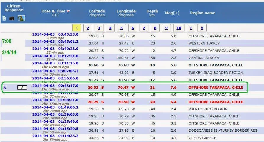
A strong 7.8-magnitude aftershock and an earlier 6.4-magnitude rocked Chile’s northern coast today (April 3)

SANTIAGO — A strong 7.8-magnitude aftershock and an earlier 6.4-magnitude rocked Chile’s northern coast today (April 3) even as Chilean authorities assessed the damage from a massive earthquake that struck off the northern coast on Tuesday.There are no immediate reports of new damage or injuries from today’s aftershocks.

Tuesday’s 8.2 magnitude quake that shook northern Chile on Tuesday killed six people and triggered a tsunami with 2m waves.

As the ocean waves receded, over 900,000 people who had evacuated the country’s low-lying coastal areas returned to their homes, some to find their houses and livelihoods in ruins.More than 2,600 homes were damaged and fishing boats along the northern coast were smashed up. However, most infrastructure held up and mines in the world’s No. 1 copper producer were generally functioning normally.The arid, mineral-rich north is sparsely populated, with most of the population concentrated in the port towns of Iquique and Arica, near the Peruvian border.In Peru, the earthquake led to temporary power outages and evacuations in some southern towns, but did not cause serious damage or injuries.Chilean President Michelle Bachelet visited Iquique yesterday and praised people’s orderly response to the emergency.“We are here to recognise the calm behaviour of the people of Iquique who showed great civic responsibility, as did those of Arica. I think you have given us all a tremendous example,” she said.The government would put great effort into restoring services, she added.Finance Minister Alberto Arenas said the government would place “no limit on the use of resources to address this emergency.”Ms Bachelet, who was sworn in as president less than a month ago, is likely conscious of the stinging criticism she faced near the end of her first term in office in 2010, when the government was seen to have responded inadequately to a much bigger 8.8 quake and tsunami that killed over 500 people.

  • DAMAGE LIMITED
It was too early to estimate financial losses, but they were expected to be much lower than the US$30 billion (S$38 million) from the 2010 quake, which affected the more densely populated central region, said earthquake expert Alexander Allmann at reinsurer Munich Re.“The quake has caused severe damage to some buildings in the affected region, but in general the building standards in Chile are comparatively high, allowing buildings and infrastructure to withstand such quakes reasonably well,” said Mr Allmann.“The small tsunami triggered by the quake is not expected to have caused significant damage.”Small fishing vessels in the ports appeared to be among the worst affected.“We struggled just to be able to get a bigger boat and now look at it,” a woman from Iquique’s fishing community, in tears, said in a video posted on Reuters.Several smaller aftershocks, some as big as 5.2 magnitude, continued yesterday and some ports in the area remained closed........http://www.todayonline.com/world/americas/chile-assesses-damage-after-massive-quake?singlepage=true
3/4/14
--
-


Τετάρτη 2 Απριλίου 2014

A strong 8.2-magnitude earthquake has struck off the northwestern coast of Chile...

A strong 8.2-magnitude earthquake has struck off the northwestern coast of Chile, killing at least two people and setting off a small tsunami that prompted evacuations along the country's Pacific coast.

The U.S. Geological Survey says the earthquake was centered about 100 kilometers northwest of Iquique Tuesday evening. It was followed by several aftershocks, including one measuring 6.2-magnitude.

Chilean authorities said waves measuring about two meters were striking cities along the coast. Officials quickly ordered evacuations, warning that larger waves are expected later.

Iquique's governor, Gonzalo Prieto, told a local radio station that two people are confirmed dead and at least three are seriously injured.

  • There have been no reports of widespread damage. But Chile's emergency office said the earthquake has caused landslides that are partially blocking some roads and highways.

A tsunami alert has been issued for the entire Pacific coast of Central and South America.
  • U.S. officials say they have found no imminent threat of a tsunami along the coasts of Hawaii, Alaska, California, Oregon or Washington state after the earthquake near Chile, but the danger is still under evaluation.

  • Chile is one of the world's most earthquake prone countries. In 2010, a 8.8-magnitude quake rocked central Chile, killing over 500 people and destroying 220,000 homes.

The region hit by Tuesday's quake had also experienced several smaller temblors in recent days, including a 6.0-magnitude earthquake on Sunday. 
 [voanews.com]
2/4/14
--------------------------
  • M 8.0 - OFFSHORE TARAPACA, CHILE .... 93 km NW of Iquique, Chile ....local time: 19:46....
MagnitudeMw 8.0
RegionOFFSHORE TARAPACA, CHILE
Date time2014-04-01 23:46:49.0 UTC
Location19.72 S ; 70.86 W
Depth33 km
Distances457 km SW of La Paz, Bolivia / pop: 812,799 / local time: 19:46:49.0 2014-04-01
93 km NW of Iquique, Chile / pop: 227,499 / local time: 19:46:49.0 2014-04-01
Global view
Source parameters reviewed by a seismologist

--------------------------------

  • M8.2 - 95km NW of Iquique, Chile

Event Time

  1. 2014-04-01 23:46:46 UTC
  2. 2014-04-01 18:46:46 UTC-05:00 at epicenter
  3. 2014-04-02 02:46:46 UTC+03:00 system time

Location

19.642°S 70.817°W depth=20.1km (12.5mi)

Nearby Cities

  1. 95km (59mi) NW of Iquique, Chile
  2. 139km (86mi) SSW of Arica, Chile
  3. 190km (118mi) SSW of Tacna, Peru
  4. 228km (142mi) SSE of Ilo, Peru
  5. 447km (278mi) SW of La Paz, Bolivia
---- 

 
--

Οι νεκροί Έλληνες στα μακεδονικά χώματα σάς κοιτούν με οργή

«Παριστάνετε τα "καλά παιδιά" ελπίζοντας στη στήριξη του διεθνή παράγοντα για να παραμείνετε στην εξουσία», ήταν η κατηγορία πο...