Thousands of people have been evacuated from their homes after flash floods caused by heavy rains hit northwestern Greece, southern Albania and northwest of Turkey... About 1,500 people had to be evacuated from their villages to safer zones after torrential rains hit the northwest Turkish province of Edirne on the border with Greece, causing the Tunca and Meric riverbeds to overflow, officials said Monday.
Four villages and several isolated farmhouses close to the city of Arta in Greece were also evacuated after heavy rains swept across the northwestern province of Epirus.
The historic Plaka Bridge near Arta also collapsed after at least four rivers in the region burst their banks, three of them near Arta and another closer to Greece's border with Albania. [www.aa.com.tr] 2/2/15 -- -
A winter storm has brought flooding to parts of Greece and southern Albania.
No fatalities have been reported in either country, but considerable disruption has been caused by a combination of torrential rain and strong winds. Rain began falling in Greece’s northwestern province of Epirus on Saturday, prompting the authorities to evacuate people from four villages near the city of Arta.
By Sunday, four rivers in the area had overflowed.
One high-profile casualty of the flooding was the Plaka Bridge, the largest arch bridge in the Balkans. The bridge, which spans the Arachthos River, was built by Konstantinos Bekas in 1866. It is reported that the whole of the central section of the bridge was washed away.
In southern Albania, scores of families and their livestock were moved from homes and farms in Vlore, Fier, Berat and Gjirokaster, south of the capital, Tirana.
In Gjirokaster, 220mm of rain fell between Saturday and Monday, more than would normally be expected in the whole of February.
In coming days, further troughs of low pressure moving through the Mediterranean could bring another 100mm to 150mm of rain to coastal areas of southern Albania and northwestern Greece. Source: Al Jazeera 2/2/15 -- - Related:
A tugboat arrived Saturday night to tow the disabled Russian container ship carrying hundreds of tons of fuel further away from Canada's British Columbia shores and into more sheltered waters, a spokesperson with the Canadian Forces' Joint Rescue Coordination Center said. "When they get the vessel under tow, they'll first head in a northwesterly direction and get it further from the coastline and eventually into more sheltered waters to the north of Haida Gwaii… Then a decision will be made on where to take it," Navy Lt. Pendergast told Canadian TV news channel CTVNews. He said the Barbara Foss tugboat arrived in the area after 5 p.m. local time and was hooking onto the drifting Simushir vessel.
Officials said there was no risk of the ship hitting rocks after it was moved 24 nautical miles (44 kilometers) away from the rocky shore. Fears were it could spill its cargo of 400 metric tons of bunker fuel and 60 metric tons of diesel, triggering an environmental disaster. On Friday, British Columbia Environment Minister Mary Polak said "the province is also contacting its partners in the B.C. Pacific States Oil Spill Task Force both to notify them of the risk and to ask them to provide mutual aid as needed based on the outcome of efforts to restore power to the vessel".
The Simushir carrier ship, with a crew of 11, was going from the US state of Washington to Russia when it lost power on Friday morning. The captain was injured and rescued from the vessel.
British Columbia still remembers the massive oil spill that occurred near Alaska in 1989, when Exxon Valdez oil tanker struck Bligh Reef and spilled 260,000 to 750,000 barrels of crude oil over the next days. (RIA Novosti) 19/10/14 -- -
Canadian and US coast guards have been struggling to tow a 135-meter Russian cargo ship after it lost power in gale force wind conditions. As 450 tons of bunker oil and diesel were on board the ship, the situation prompted fears of an ecological disaster.
Cargo ship Simushir went adrift on Thursday off the West coast of Haida Gwaii, located near British Columbia. The vessel left Everett, Washington and was bound to Russia.
As the ship became incapacitated amid the storm, its plight raised an alarm in the regional media, as 400 tons of oil and about 50 tons of diesel fuel it was carrying were deemed enough for an environmental catastrophe, in case the vessel ran aground...............................http://rt.com/news/197192-ship-adrift-oil-canada/
Taiwan has begun cleanup efforts after Tropical Storm Fung-Wong pounded the island with massive downpours, while China braced for the onslaught of the upgraded Typhoon Fung-Wong.
The powerful storm arrived in Taiwan Sunday, pounding the north and south of the island but causing only limited damage. It blew into the South China Sea Monday morning, leaving at least one person dead and four injured. East China's Zhejiang Province faced a strengthened storm as Fung-Wong made landfall Monday afternoon.
Authorities say more than 157,000 people have been evacuated from coastal areas.
Fung-Wong, which means "phoenix" in Chinese, caused severe damage when it moved through the Philippines Friday and Saturday, killing at least five people.http://www.voanews.com/content/powerful-storm-blows-through-taiwan-hits-china/2457819.html 22/9/14 -- - Related:
Typhoon Fung-Wong, which was enhanced by southwest monsoon, left at least seven people dead in the northern parts of the Philippines, including Metro Manila, the state disaster management agency said Saturday.
In its 8:00 a.m. report, the National Disaster Risk Reduction and Management Council said that six other people were injured, while one was missing. Of those who died, two were female and the rest were male, who were either drowned, electrocuted or hit by falling objects.
A 55-year old male was reported missing in Quezon City, Metro Manila.
A total 118,839 families or 530,438 persons were affected by the storm, of which 23,581 families or 93,062 individuals were inside 181 evacuation centers.
Some areas in the provinces of Apayao, Abra, Benguet, Ilocos Norte, Ilocos Sur, La Union, Pangasinan, Laguna and Occidental Mindoro were experiencing power interruption.
A total of 2,400 passengers, 15 vessels, 254 rolling cargoes were stranded in central region of Visayas due to rough sea condition.
Meanwhile, 46 flgihts, six international and 40 domestic, were diverted or canceled.
An estimated 87 roads and five bridges are still not passable in the capital region of Metro Manila and southern Luzon island. Sources: Xinhua - globaltimes.cn 20/9/14 -- - Related:
A tropical storm dumped heavy rain on the Philippine capital on Friday, flooding many parts of the city, shutting schools, government offices and financial markets.
Thousands of residents in low-lying areas were moved to higher ground, officials said, as flood waters rose quickly after the equivalent of half a month's usual rain fell in six hours.
The Philippine Stock Exchange suspended trade after the government cancelled work and classes in the capital. Trading at the electronic foreign exchange platform Philippine Dealing System was also suspended, with clearing and settlement cancelled for the day.
Tropical storm Fung-Wong, with maximum winds of 85 kph (50 mph) and gusts of up to 100 kph (62 mph), was hovering about 210 km (130 miles) east of Casiguran town in northern Aurora province.
It is expected to hit land at around noon on Friday and move northwest at 22 kph (13 mph) towards the South China Sea.
About 7,000 people were evacuated in Marikina City in the eastern part of the capital where a swollen river caused flooding, said Del De Guzman, city mayor.
"We are now on sweeping operations for those trapped by the floods. The rains were so heavy, so fast, some were not able to evacuate," De Guzman said in an interview with GMA TV, adding the government was sending amphibious vehicles and rubber boats to help get people out. http://indian.ruvr.ru 19/9/14 -
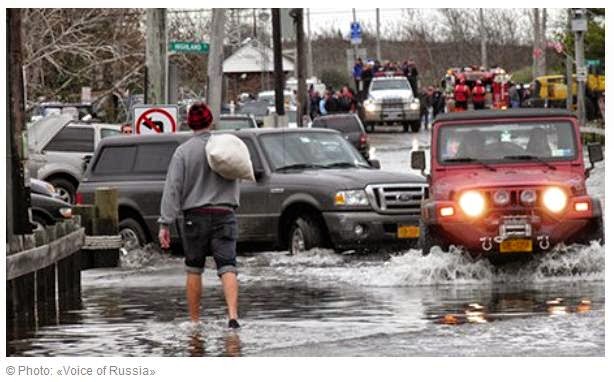
US authorities announced the evacuation of residents of Hatteras Island in North Carolina because of the approaching tropical storm "Arthur." This was announced today that the regional emergency service. Start of the evacuation of residents and visitors of the island is scheduled for 5:00 Thursday local time (13:00 MSK). Gusts of wind, rough seas and flooding of the highway connecting the island to the mainland are expected in the region.
"All residents and visitors of the island are advised to leave it as soon as possible during the day," it says in the message. Earlier storm alert was issued in the state. According to experts from the National Centre for Monitoring hurricanes in Miami, "Arthur" continues to gain strength and will turn into a hurricane on Thursday.
For now it is unclear where exactly it would hit the land, but scientists believe that it might happen right next to Cape Hatteras.
East Coast residents fear that "Arthur" can ruin their plans to celebrate on Friday one of the major US national holidays, Independence Day. Americans often spend this day outdoors, having picnics with friends. In many cities, including Washington and New York, colorful fireworks are usually taking place. This year heavy rains and strong winds might cancel these plans.
The hurricane season in Atlantic usually lasts from June 1 to November 30. It is expected that this year it will not be very active. According to the meteorologists’ forecasts, from 8 to 13, tropical storms will be started over the Atlantic. About three or six of them will turn into hurricanes, and one or two will grow up to the third category of danger according to the Saffir-Simpson scale.
Atmospheric phenomenon is classified as a storm and gets its own name, if the wind speed reaches its epicenter at 63 kilometers per hour. Storm becomes a hurricane when wind speed reaches 118 km per hour. [voiceofrussia.com] 3/7/14 -
CHICAGO: A fast-moving storm system that produced at least one tornado in Illinois threatened some 53 million people across 10 Midwestern states on Sunday, US weather officials said.
"A confirmed large and extremely dangerous tornado" was spotted near Washington, Illinois, located about 145 miles (233 kilometers) southwest of Chicago, the National Weather Service said.
Photos taken at the scene showed structures were reduced to rubble and houses ripped open in Washington, Illinois.
"There is a lot of debris," Sara Sparkman, a spokeswoman for the health department of Tazewell County, Illinois, where Washington is located, told The Weather Channel. "We do know that shelters are being set up in some of the communities because people are being displaced out of their homes because of the storms that hit."
Sparkman added that the storm had caused damage in Washington and Pekin, south of Peoria.
It came out of a fast-moving storm system that was headed toward Chicago and threatened a large swath of the Midwest with dangerous winds, thunderstorms and hail, U.S. weather officials said.
The weather service warned residents of areas threatened by the storm "you are in a life-threatening situation .... take cover now."
At Chicago's Soldier Field, where the NFL's Bears were playing the Baltimore Ravens, officials halted play and told fans to seek shelter due to hazardous weather conditions.
"It does appear that the hardest hit part of the state was down south," Mike Masters, head of homeland security in Cook County, which includes Chicago, told Chicago's ABC-7 TV, cautioning that it was still "very, very early."
The Chicago Department of Aviation, which manages O'Hare International Airport and Midway International Airport, said that as of 1:15 p.m. Central Time (1915 GMT) both facilities were at a ground stop, meaning flights were neither arriving nor departing.
"We obviously have a very dangerous situation on our hands and it's just getting started," Laura Furgione, deputy director of the National Weather Service, told reporters on a conference call.
Tornado warnings were in effect for parts of Illinois, Kentucky, Missouri. Weather officials urged residents of areas with tornado warnings in place to take cover in interior, low-floor rooms of study buildings.
The NWS's Storm Prediction Center said the storm was moving dangerously fast, tracking eastward at 60 miles an hour (97 kph), meaning that just looking out at the storm will not be enough to let people know when to take cover.
"These storms will be moving very fast, approximately 60 miles an hour," said Russell Schneider of the Storm Prediction Center. "They will be at your location and on to the next location in a matter of minutes. As a result, people cannot wait for visual confirmation of the threat."
This storm system has some similarities to the fast-moving derecho that knocked out power to more than 4.2 million people and killed 22 in June 2012, according to Bill Bunting, forecast branch chief at the Storm Prediction Center.
"The line of storms today, we believe, when it's fully mature, will actually be larger than the areas that were affected by the derecho in June of 2012," Bunting said. "However, this will also be accompanied by a worse tornado threat in the areas that we've highlighted and large hail in Illinois and Wisconsin." timesofindia.indiatimes.com ---- Photos: http://www.mirror.co.uk/news/world-news/midwest-storm-shocking-pictures-show-2802903 18/11/13 ---
China’s meteorological authority has issued an alert for super typhoon Usagi that is expected to hit the country’s southern coast.
Usagi was upgraded to a super typhoon at around 5 p.m. Beijing time on Thursday. This is the strongest classification for a Typhoon.
It has been predicted to hit the coastal region between China’s Guangxi Zhuang Autonomous Region and southeastern Fujian Province on Sunday evening.
In response, the State Oceanic Administration has initiated an I-class emergency response for the typhoon, the highest level of the nation's maritime disaster response system. The Administration says Usagi may become one of the strongest typhoons to hit China’s southeastern coast this year. english.cntv.cn 20/9/13 ----
Powerful typhoon hits Taiwan, Philippines...
TAIPEI, Taiwan: The most powerful typhoon of the year was sweeping through the Luzon Strait on Saturday, battering island communities and drenching southern Taiwan and the northern Philippines. Super Typhoon Usagi had maximum sustained winds of 222 kph (139 mph) and gusts exceeding 260 kph (163 mph) early Saturday, and was 550 kilometers south of Taipei, Taiwan's capital, according to the US Navy's Joint Typhoon Warning Center. A storm achieves super typhoon status when winds reach 240 kph (150 mph). In the Philippines, Usagi triggered landslides and power outages in parts of the north of the country, including Batanes province where it made landfall early Saturday. No casualties have been reported. China's National Meteorological Center announced a red alert, the observatory's highest, as the storm maintained its track toward Hong Kong and the Pearl River Delta. The observatory warned Usagi will impact coastal areas of Zhejiang and Fujian provinces. The US Navy's warning center predicted that Usagi will make landfall near Hong Kong with weaker but dangerous sustained winds of 180 kph (113 mph) early Monday morning. In Taiwan, nearly 2,500 people were evacuated from flood-prone areas and remote mountainous regions. Torrential rains were reported along the eastern coast and in the south as officials warned of cumulative rainfall of 1,000 millimeters (39 inches) along the east coast. Usagi retains a massive diameter of 1,100 kilometers (680 miles), with its outer rain bands extending across the main northern Philippine island of Luzon and all of Taiwan. Taiwan's Central Weather Bureau warned winds of 100 kph (63 mph) could hit Taipei. The Office of Civil Defense in Manila said at least five families had to be evacuated from their homes in mountainous Benguet province after several landslides damaged houses and roads. Pockets of power outages were reported in at least five northern provinces, where several roads and bridges were impassable. The government's weather bureau said Usagi was forecast to blow out of Philippine territory by Saturday evening. In Hong Kong, Cathay Pacific Airways said Saturday that flights are unaffected but warned of delayed and canceled flights from Sunday evening to Monday morning. The airline urged passengers to postpone non-essential travel on those two days.
Οι κάτοικοι της πόλης Ταμπούκ στα βόρειο-δυτικά της Σαουδικής Αραβίας ήρθαν αντιμέτωποι με το χιόνι, ένα πολύ σπάνιο φυσικό φαινόμενο για αυτή την περιοχή.
Στα βίντεο που μεταδίδει το διαραβικό τηλεοπτικό κανάλι «Al Arabiya», παρουσιάζονται οι εικόνες των αυτοκινήτων, που με δυσκολία περνούν μέσα από τους χιονισμένους δρόμους.
Για να δούνε αυτό το σπάνιο φαινόμενο, στο Ταμπούκ ήρθαν οι κάτοικοι των γειτονικών πόλεων. Στην περιοχή έχουν μεταφερθεί επιπρόσθετες μονάδες αστυνομίας και των υπηρεσιών έκτακτης ανάγκης για την διασφάλιση της ασφάλειας. http://greek.ruvr.ru/2013_01_10/100678523/ 10/1/13 ---
Residents enjoy rare snowfall in northwest Saudi (+VIDEO)
Residents of Tabuk are enjoying the rare snowfall that has hit the northwestern region of Saudi Arabia. People have been spotted parked around the mountain region which has been covered by a sheet of white snow. Cars have crowded the roads leading to Mount Alluz. The area is teeming with visitors from several cities in the region who have traveled to get a glimpse of the unexpected snowfall. Traffic patrol, security as well as emergency services have been deployed in the area to assure safety. Saudi officials have warned residents to avoid the valleys and areas affected by flooding. Snowfall has also hit the region bordering Jordan, especially the villages of Tafha, Nagira and Ghouson. http://english.alarabiya.net/articles/2013/01/10/259727.html 10/1/2013 -----------
Deadly storms blanket parts of Mid-East in snow (VIDEO BBC)
11 January 2013 Last updated at 04:39 GMT Help
The worst storms to hit the Middle East in a decade have claimed several lives and left large parts of Israel and Jordan blanketed in snow.
Across the region, many schools are shut and thousands of homes are without power.
The freezing conditions have brought misery for thousands of Syrians living in refugee camps in northern Jordan, Turkey and Lebanon.
James Kelly reports. http://www.bbc.co.uk/news/world-middle-east-20981607
11/1/13 ---------------
Saudi Arabia covered with snow in coldest winter for 20 years (11-1-2008)
ABU DHABI, January 11 (RIA Novosti) - Northern parts of Saudi Arabia are covered with snow with schools, mosques and administrative bodies paralyzed, local media reported Friday.
The oil-rich kingdom is being hit with subzero temperatures and snow storms with freezing winds of up to 50 km/h (30mp/h). Some regions have been experiencing problems with water supplies as pipes have frozen, and livestock has died from the cold.
The Saudi Gazette reported late in December that the winter was expected to last 89 days, with temperatures reaching below zero. National media said the winter is the coldest in the country for 20 years.
Morning and afternoon prayers are being combined in many mosques because of the morning cold and some schools will reopen later than scheduled.
The bad weather is fun for children and teenagers, however, who have been making snowballs and building snowmen with enthusiasm. http://en.rian.ru/world/20080111/96210251.html ------------------------->11/1/2008<-------------------------
Ειδικοί ετοιμάζονται να προσδέσουν συρματόσχοινο για ρυμούλκηση στην πλωτή εξέδρα γεώτρησης Kulluk, που ανήκει στην πετρελαϊκή εταιρεία Royal Dutch Shell. Η εξέδρα ρίχτηκε από τα κύμματα στις ακτές της Αλάσκας στις 31 Δεκεμβρίου, όταν μετά από μία σφοδρή καταιγίδα αποκόπηκε από το ρυμουλκό πλοίο και παρασύρθηκε. Πάνω στην εξέδρα βρίσκονται πάνω από 500 χιλ. λίτρα πετρελαίου και ντίζελ. Προς το παρόν δεν υπάρχουν ενδείξεις διαρροής. Ωστόσο, στην εξέδρα βρέθηκε θαλασσινό νερό, γεγονός που υποδεικνύει ότι η εξωτερική επένδυση μπορεί να έχει υποστεί βλάβη. .ruvr.ru 6/1/13 -- ΣΧΕΤΙΚΑ- VIDEO:
A Coast Guard MH-60 Jayhawk helicopter crew overfly the conical drilling unit Kulluk Shell's Kulluk platform aground on the southeast shore of Sitkalidak Island about 40 miles southwest of Kodiak City, Alaska, Tuesday, Jan. 1, 2013. The on scene weather conditions were 40 mph winds with 20-foot seas. U.S. Coast Guard video by Petty Officer 1st Class Sara Francis.
Σταμάτησε η διαρροή από την πλατφόρμα εξόρυξης πετρελαίου Kulluk της Shell, η οποία προσέκρουσε σε στεριά κατά τη ρυμούλκησή της από την Αρκτική προς την Αλάσκα πριν από λίγες μέρες, γεγονός που καθιστά ευκολότερη την διαδικασία ρυμούλκησης, ανακοίνωσαν αργά χθες το βράδυ αξιωματούχοι. Έξι εμπειρογνώμονες επωφελήθηκαν από την μικρή βελτίωση του καιρού για να προσεγγίσουν το κατάστρωμά της, ανακοίνωσε ο επικεφαλής της αμερικανικής ακτοφυλακής Πολ Μέλερ. Την Δευτέρα, η πλατφόρμα προσέκρουσε στη στεριά όταν το παγοθραυστικό που την ρυμουλκούσε υπέστη μηχανική βλάβη εν μέσω καταιγίδας. Η πλατφόρμα Kulluk διαμέτρου 81 μέτρων μετέφερε 540.000 λίτρα ντίζελ και 45.000 λίτρα πετρελαίου λίπανσης, δήλωσε η Ντάρσι Σενκλέρ, εκπρόσωπος του κέντρου διοίκησης της ακτοφυλακής που έχει αναλάβει τον χειρισμό του ατυχήματος. Και τα 18 μέλη του πληρώματος της 290 εκατομμυρίων δολαρίων πλατφόρμας της Shell διασώθηκαν. Την πλατφόρμα ρυμουλκούσαν προς το Σιάτλ για συντήρηση όταν προσέκρουσε στη στεριά στην ανατολική ακτή του ακατοίκητου νησιού Σιτκαλιντάκ στον Κόλπο της Αλάσκας. .energypress.gr 3/1/13 -- ΣΧΕΤΙΚΑ:
Πλατφόρμα που μετέφερε τρυπάνι της πετρελαϊκής εταιρείας Shell προσάραξε την περασμένη Δευτέρα στις ακτές της Αλάσκας, λόγω κακοκαιρίας. Σύμφωνα με ανακοίνωση αξιωματούχων της εταιρείας και της κυβέρνησης το πλοίο «Kulluk» ξέφυγε από την πορεία του και χτύπησε σε βράχια κοντά στο νησί Κόντιακ. Τα 18 μέλη του πληρώματος είχαν ήδη εγκαταλείψει το πλοίο από το Σάββατο με τη συνδρομή της Αμερικανικής Ακτοφυλακής λόγω των κινδύνων από τις κακές καιρικές συνθήκες, καθώς έπνεαν άνεμοι με ταχύτητα 100 χιλιόμετρα την ώρα και η στάθμη της θάλασσας στον Κόλπο της Αλάσκας είχε ανέβει κατά 11 μέτρα. .protothema.gr 2/1/13 --- - ΣΧΕΤΙΚΑ:
Photograph courtesy Sara Francis, U.S. Coast Guard
The oil rig Kulluk is seen here at sea on Saturday, 80 miles south of Kodiak, as its crew is airlifted to safety. The 20-year-old conical rig was named in 1982 by an Inuvik schoolgirl; the word means "thunder" in her native language. The ship has a draft of 41 feet (13 meters); it is beached in water that is 24 to 48 feet deep (7 to 15 meters), about 1,648 feet (500 meters) from shore, says the Coast Guard (see map). The Coast Guard says that the Kulluk is upright and stable with no signs of environmental impact. But on Tuesday, Alaska Department of Environmental Conservation official Steve Russell warned, "The Kulluk still presents a significant threat to Ocean Bay and the surrounding areas." The joint government-industry task force, the Unified Command, planned multiple flyovers on Wednesday to assess the site. Once conditions are deemed safe, the plan is to place a team aboard the vessel to get a better view of its condition. But weather conditions continued to be severe, with flight restrictions in place. The Coast Guard was maintaining a safety zone of one nautical mile around the vessel this morning. The Coast Guard said it had no immediate estimate of the costs of the response operations, but said that Shell was assuming responsibility for the effort. Coast Guard Captain Paul Mehler said the response effort had benefited from the extensive oil-spill planning and joint training in advance of Shell's first Arctic drilling last summer. But when asked if the plans had ever anticipated events like those unfolding this past week, he said, "This particular scenario—certainly not. I don't think we could have come up with a scenario as this has played out. This has been that challenging."
Η διάσωση της εξέδρας γεώτρησης της Shell αναβάλλεται
Οι προσπάθειες διάσωσης της εξέδρας γεώτρησης της εταιρείας Royal Dutch Shell, που κάθισε στα αβαθή στις ακτές της Αλάσκας αναβλήθηκαν για αργότερα λόγω των ισχυρών ανέμων, μεταδίδει το BBC. Η πλωτή εξέδρα γεώτρησης Kulluk παρασύρθηκε στα ανοικτά των ακτών της Αλάσκας και προσάραξε στις νήσους Κόντιακ τη Δευτέρα. Σύμφωνα με την αμερικανική Ακτοφυλακή, η κατάσταση προς το παρόν δεν είναι επικίνδυνη. Στις 30 Δεκεμβρίου κατά τη διάρκεια καταιγίδας η εξέδρα άρχισε να πλέει ανεξέλεγκτα αφότου υπέστησαν βλάβη οι κινητήρες του πλοίου ρυμούλκησής της. Το πλήρωμα της εξέδρας Kulluk απομακρύνθηκε όταν προέκυψε κίνδυνος σύγκρουσης με ένα από τα νησιά.
An overnight Coast Guard flight over an Alaska drilling rig that ran aground in shallow water off a small island on New Year's Eve found no signs of a fuel spill. But officials at a unified command center run by the Coast Guard, Royal Dutch Shell PLC, state responders and others said they'll have to wait until daylight to know for sure what environmental impact the grounding might have caused.
The Kulluk grounded Monday night on rocks off the southeast side of Sitkalidak Island, an uninhabited island in the Gulf of Alaska.
The North Pacific storm that has caused problems for Shell's efforts to move the drill into place near Kodiak Island is expected to continue Tuesday, at a slightly milder intensity, said spokeswoman Darci Sinclair.
Voice of Russia, AP ruvr.ru 1/1/13 --- - Related post:
Alaska (AP) — Royal Dutch Shell PLC's foray into Arctic offshore drilling has suffered a serious setback after one of its two Alaska drilling rigs ran aground in shallow water off a small island. Officials at a unified command center run by the Coast Guard, Shell, state responders and others said the Kulluk grounded Monday night on rocks off the southeast side of Sitkalidak Island, an uninhabited island in the Gulf of Alaska. The Kulluk was being towed by a 360-foot anchor handler, the Aiviq, and a tugboat, the Alert. The vessels were moving north along Kodiak Island, trying to escape the worst of a North Pacific storm that included winds near 70 mph and swells to 35 feet. Sitkalidak is on the southeast side of Kodiak Island. About 4:15 p.m., the drill ship separated from the Aiviq about 10 to 15 miles off shore and grounding was inevitable, Coast Guard Cmdr. Shane Montoya, the acting federal on-scene coordinator, told reporters. "Once the Aiviq lost its tow, we knew the Alert could not manage the Kulluk on its own as far as towing, and that's when we started planning for the grounding," he said. The command center instructed the nine tug crew members to guide the drill ship to a place where it would cause the least environmental damage. The tug cut the unmanned ship loose at 8:15 p.m. and it grounded at 9 p.m. near the north tip of Ocean Bay on Sitkalidak. "The Alert was not able to do anything as far as towing the Kulluk but tried to maintain some kind of control," Montoya said. The drill ship drafts 35 to 40 feet of water. The Coast Guard planned to fly out early Tuesday to plan a salvage operation and possible spill response. It is carrying 150,000 gallons of diesel and about 12,000 gallons of lube oil and hydraulic fluid, Montoya said. Susan Childs, Shell's on-scene coordinator, said it was too early to know how the vessel would react to the pounding of the storm when it was aground and stationary. She was optimistic about its salvage prospects and chances for staying intact. "The unique design of the Kulluk means the diesel fuel tanks are isolated in the center of the vessel and encased in very heavy steel," she said. "When the weather subsides and it is safe to do so, we will dispatch crews to the location and begin a complete assessment." The Kulluk is designed for extended drilling in Arctic waters and underwent $292 million in technical upgrades since 2006 to prepare for Alaska offshore exploration. The drill ship worked during the short 2012 open water season in the Beaufort Sea off Alaska's north coast. Its ice-reinforced, funnel-shape hull can deflect moving ice downward and break it into pieces. Attached to a drilling prospect, the Kulluk is designed to handle waves 18 feet high. When disconnected from a well, it's designed to handle seas to 40 feet. Garth Pulkkinen of Noble Corp., the operator of the drill ship, said it was never in danger of capsizing. The vessel first separated from a towing vessel Thursday night south of Kodiak Island. It was carrying a skeleton crew of 17 as it was towed by the Aiviq from Dutch Harbor in the Aleutian Islands to Seattle for maintenance. The tow line broke at a shackle attached to one of the vessels. "It was new. It was inspected before it left Dutch, but it broke," said Shell Alaska spokesman Curtis Smith. Before a line could be reattached, the Aiviq's engines failed, possibly from contaminated fuel. The Coast Guard cutter Alex Haley attempted to secure the drifting drill ship but that line failed and wrapped itself around one of the cutter's propellers, requiring the cutter to return to Kodiak on one propeller. With bad weather predicted, the Kulluk's crew was evacuated Saturday. They hooked up emergency tow lines and left them trailing behind the vessel in case they were needed. The Aiviq, with its engines restored, and a tug re-established lines to the drill ship, but lines broke Sunday. During a lull in the storm early Monday, the crew of Alert grabbed the original 400-foot line trailing the drill ship and later the Aiviq grappled aboard one of the emergency lines. .npr.org 1/1/13




 GR
GR FR
FR DE
DE ES
ES IT
IT RU
RU EU
EU